Haiti sits on the western third of Hispaniola, where two rugged peninsulas wrap around the Golfe de la Gonâve and create bays, coves, and sheltered harbors. Nearly two-thirds is mountainous, topped by Morne de la Selle (2,680 m) and Pic Macaya in the Massif de la Hotte.
Fertile lowlands like the Artibonite Plain and Northern Plain support farming along the Artibonite River. Climate shifts with altitude, with a drier November–March and wetter June–October, plus hurricane and quake risks—there’s more ahead on standout natural landmarks.
Key Takeaways
- Haiti occupies western Hispaniola, split into two peninsulas around the Golfe de la Gonâve, creating bays, headlands, and sheltered harbors.
- About two-thirds is mountainous; Morne de la Selle reaches 2,680 meters, and Pic Macaya rises in the Massif de la Hotte.
- Agriculture concentrates in lowlands: the Artibonite Plain and Northern Plain, plus the Cul-de-Sac and Central Plateau holding over half cultivated land.
- Coasts mix cliffs, sandy coves, and offshore coral reefs; Gonâve Island sits in the gulf, supporting lagoons and productive fishing grounds.
- Climate shifts with altitude and wind exposure; wet season runs June–October, drier November–March, with hurricane and earthquake risks near Port-au-Prince.
Haiti Geography Overview: Regions and Key Landmarks
Where does Haiti’s geography make its strongest impression? It’s in the sharp contrasts packed into the western third of Hispaniola: two peninsulas split by the triangular Golfe de la Gonâve, rocky coasts with cliffs, reefs, and sheltered harbors, and the broad productive lowlands.
The Northern Plain lines the coast, while the Artibonite Plain anchors much of crop production. Inland, the Cul-de-Sac and Central Plateau hold over half the cultivated area. Water landmarks include the 175-mile Artibonite River and Étang Saumâtre, a saline lake known for wildlife. The region’s history as the first Black Republic is tied to its geography and agricultural potential, influencing settlement patterns and resilience. Artibonite River
Haiti’s Mountains: Ranges, Peaks, and Towns
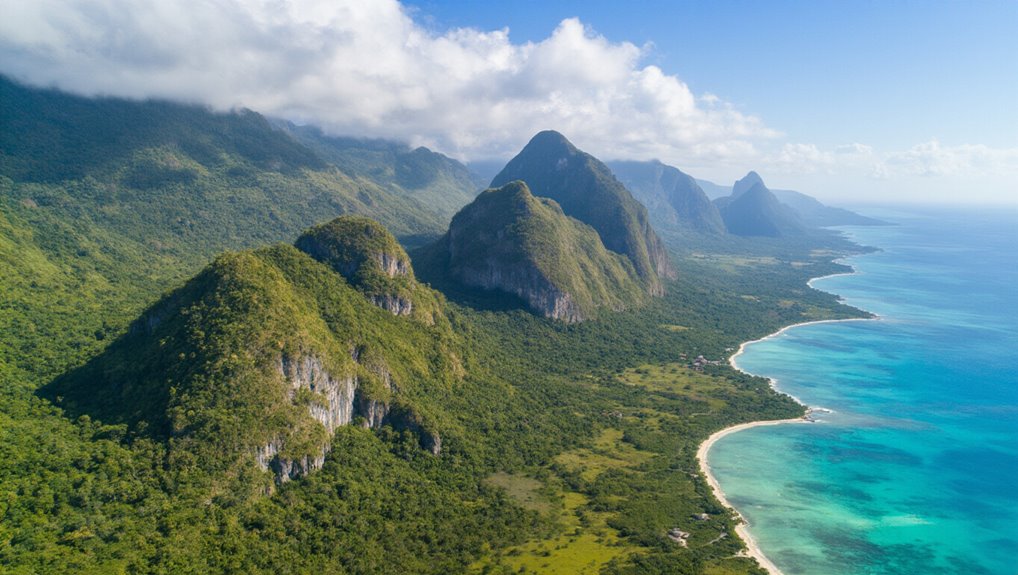
Haiti’s terrain answers with rugged chains that make two-thirds of the country mountainous, while five ranges cover about 75 percent of its land. Seven main belts include the Massif du Nord and the Massif de la Selle, where Morne de la Selle rises to 2,680 meters (8,790 feet), the nation’s high point.
The Massif de la Hotte holds Pic Macaya at 2,347 meters (7,700 feet). Mountain towns cling to slopes and passes, shaped by steep roads, cool air, and sudden storms, a pattern that has long influenced settlement and transport across the island. Haitian mountainous terrain forms the backdrop for the country’s climate variability and ecological zones.
Haiti’s Valleys and Plains: Where Food Is Grown
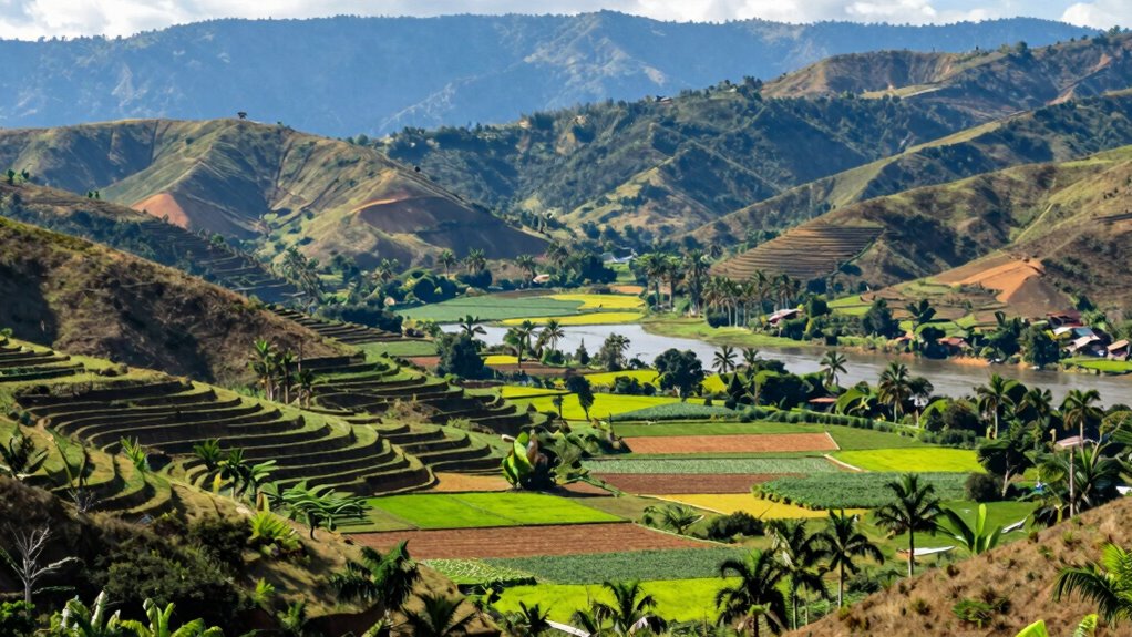
Those steep mountain belts don’t just define Haiti’s skyline—they also funnel life into the lowlands. Between rugged chains, valleys and broad plains collect deeper soils and scarce surface water, becoming the country’s food basket.
The Artibonite Plain, north of the Chaine de Mateaux, anchors most crop production, fed by the 280-kilometer Artibonite River. The Northern Plain adds fertile fields, while the Cul-de-Sac and the Central Plateau together hold over half of cultivated land. These flatter zones face floods and droughts, intensified when deforestation strips slopes and accelerates erosion. slavery legacy
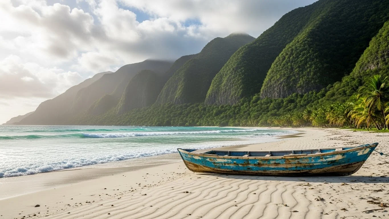
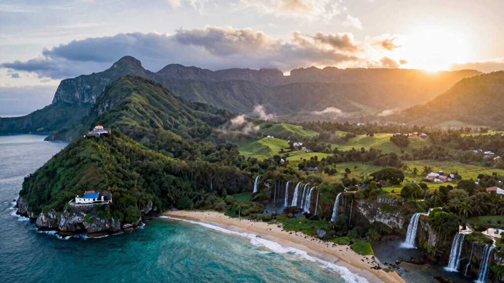
Haiti’s Coasts: Beaches, Bays, and Reefs
Across Haiti’s coast, the land breaks into two peninsulas split by the triangular Golfe de la Gonâve, giving the country a horseshoe-shaped shoreline on Hispaniola’s western third. The shorter northern arm and longer southern peninsula frame bays, headlands, and pockets of sand where beaches tuck between rocky points.
Cliffs and limestone shelves create natural harbors that have long shaped coastal settlement and travel. Offshore, coral reefs fringe parts of the shore, forming shallow lagoons and clearer water for fishing grounds. In the gulf, Gonâve Island anchors the seascape, adding coves and channels.
The coastal landscape has also supported resilient communities through changing tides and storms, underscoring the role of geography in regional livelihoods geography.
Haiti Climate by Region: Rain, Heat, and Altitude
Where Haiti feels steamiest or surprisingly mild depends on altitude and which side of the mountains a place sits on. Low coastal plains and bays stay hot and humid, while higher belts in Massif du Nord, Massif de la Selle, and the Massif de la Hotte cool noticeably, with Morne de la Selle’s heights feeling almost temperate.
Trade winds rise on windward slopes, boosting rainfall, then descend drier on leeward sides, creating semiarid pockets, especially toward the eastern mountains. Valleys like the Cul-de-Sac can run hotter, while the Central Plateau moderates heat.
The island’s diverse topography means climate patterns shift over short distances, making regional variation a hallmark of Haiti’s weather; regional climate variation influences local agriculture and living conditions across the country.
Haiti Seasons: Dry Months, Rainy Months, Hurricanes
When do Haiti’s seasons really shift from parched to storm-soaked? Generally, the drier stretch runs from November through March, when trade winds bring clearer skies and lower humidity.
Rains build in April and May, then the wet season dominates from June to October, with downpours that can trigger flash floods on deforested slopes and in low plains. Haiti also sits in the Caribbean hurricane belt, so June–October carries the highest cyclone risk, peaking from August to October. Even so, droughts can interrupt the pattern, especially in semiarid zones. Caribbean hurricane belt
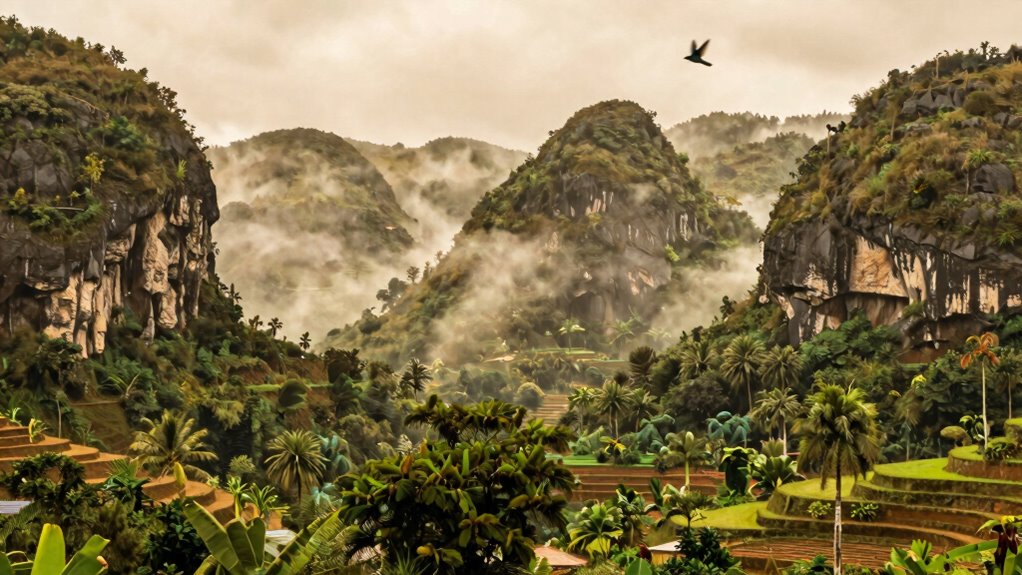
Natural Wonders in Haiti: Waterfalls, Caves, Forests
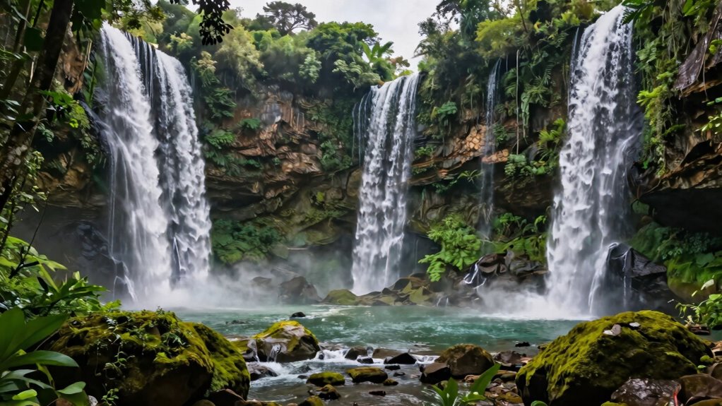
How does a country so rugged and storm-tested still manage to feel lush and otherworldly? Haiti’s mountain belts funnel rain into steep valleys, feeding waterfalls that spill from forested slopes and cool hidden pools.
In the Massif de la Hotte and around Pic Macaya, humid highlands shelter cloud-forest pockets where orchids, tree ferns, and birds thrive.
Limestone landscapes add another dimension: karst hills hide caves and grottoes, their chambers draped with stalactites and echoing underground streams.
Along the coast, coral-fringed coves and rocky cliffs frame vivid seascapes and sheltered harbors too. Karst landscapes help shape a network of caves and grottoes that echo with underground streams and reveal the country’s hidden wonders.
Natural Hazards in Haiti: Quakes, Erosion, Deforestation
Why does Haiti’s breathtaking terrain also come with such high risk?
The country sits on the boundary between the Caribbean and North American plates, and the Enriquillo–Plantain Garden Fault near Port-au-Prince can unleash destructive earthquakes. Its mountainous backbone concentrates settlement in plains and valleys, where shaking, landslides, and liquefaction hit hardest.
The long history of deforestation has increased the magnitude of these hazards, as Indemnity payments and political upheaval weakened governance and disaster planning. Deforestation worsens nearly every hazard.
With hillsides stripped, intense rains and hurricanes from June to October trigger flash floods and rapid soil loss; about one-third of land is already eroded. Droughts then follow, weakening harvests and watersheds.
Frequently Asked Questions
Do I Need a Guide for Hiking, and How Much Does One Cost?
They don’t always need a guide, but it’s recommended on remote, steep routes or where weather shifts fast. Costs vary by area and duration; they’ll often pay about $30–$80 per day, plus tips.
Which Regions Are Safest for Road Travel During the Rainy Season?
They’re safest on higher, well-maintained routes in the Central Plateau and along the Northern Plain’s main highways; they should avoid steep mountain roads and Artibonite lowlands, where floods and landslides spike during storms.
Are Drones Allowed for Coastal and Mountain Photography in Haiti?
Drones are allowed in Haiti, but operators should expect restrictions and permits, especially near airports, ports, and security sites. They should check current aviation rules, avoid crowds, and respect privacy.
What Vaccinations or Health Precautions Are Recommended for Different Regions?
They’d recommend being up to date on routine shots, plus hepatitis A and typhoid everywhere. They’d consider hepatitis B, rabies for remote mountains, and malaria meds for lowland plains/coasts; use mosquito precautions.
Can I Camp Overnight on Beaches or in National Parks Legally?
They can’t assume it’s legal; overnight beach or park camping often needs landowner or park authorization. They should ask local authorities, use established sites, and avoid protected areas without permits due to enforcement and safety concerns.
Conclusion
Haiti’s geography shapes everyday life, from rugged mountains and fertile plains to reef-lined coasts and hidden caves. Climate shifts quickly with altitude, bringing hotter, drier lowlands and cooler, wetter highlands, while seasons can swing from drought to heavy rains and hurricanes.
These landscapes hold remarkable natural wonders, yet they’re also vulnerable to earthquakes, erosion, and deforestation. Protecting watersheds, forests, and coastlines isn’t optional—it’s essential for Haiti’s future.
References
- https://itiahangels.org/six-facts-on-haitis-geography/
- https://www.worldatlas.com/maps/haiti
- https://www.worldvision.com.au/docs/default-source/school-resources/haiti-country-profile.pdf?sfvrsn=dafe3268_0
- https://www.britannica.com/place/Haiti
- https://en.wikipedia.org/wiki/Geography_of_Haiti
- https://www.freeworldmaps.net/centralamerica/haiti/map.html